
A Mississippi Genealogy & History Collection
Rodney emerged in the late 1700s along the Mississippi River, at a strategic bend that made it an ideal landing for flatboats and early river traffic. Originally known as Petit Gulf, the settlement was renamed Rodney around 1811, likely in honor of Caesar Rodney, a signer of the Declaration of Independence. By the time Mississippi achieved statehood in 1817, Rodney was already a thriving river community and one of the most promising towns in the Mississippi Territory.
Thanks to its position upriver from Natchez, Rodney quickly became a major shipping point for cotton and other agricultural goods from the interior. Warehouses, wharves, and merchant houses lined the bluff, and steamboats regularly docked at its busy landing.
During the early 19th century, Rodney was no backwater—it was a serious rival to Natchez for regional dominance. The town boasted hotels, schools, law offices, churches, and a vibrant commercial district. Wealth generated by cotton flowed through its docks, and planters from surrounding plantations used Rodney as their primary gateway to national and international markets.
At its height, Rodney was even considered a potential state capital. Had geography stayed put, Mississippi history might read very differently today.
Rodney’s fate was sealed not by war or fire, but by the Mississippi River itself. In the 1830s and 1840s, repeated flooding and a dramatic shift in the river’s course left Rodney stranded inland. The once-bustling port found itself miles from navigable water—an unforgivable sin for a river town.
Without direct river access, trade collapsed. Merchants left, businesses closed, and residents relocated to towns better aligned with the river’s new path, including Vicksburg and Grand Gulf.
During the American Civil War, Rodney briefly reentered history as Confederate forces installed artillery on the bluffs overlooking the old river channel. Despite the dramatic positioning, the town saw little direct combat. By then, Rodney’s decline was already well underway, and the war merely underscored how far it had fallen from prominence.
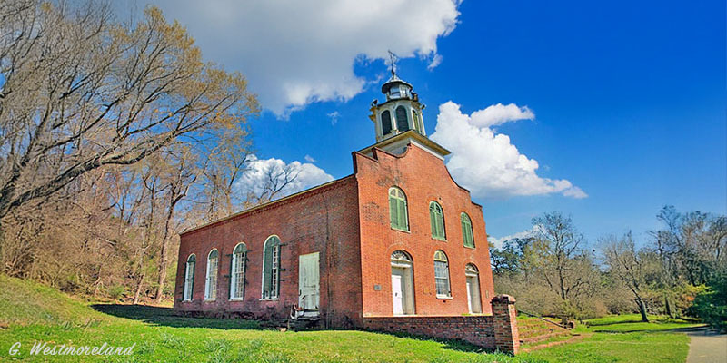
Unlike many vanished towns, Rodney never fully disappeared. A small number of residents remained, and several historic structures survived, most notably the Rodney Presbyterian Church, completed in 1832. The church, with its brick walls and simple classical lines, still stands today as one of Mississippi’s most iconic abandoned religious buildings.
Nearby cemeteries preserve generations of families who lived through Rodney’s rise and decline—planters, merchants, enslaved people, and later rural residents who stayed long after the river moved on.
Today, Rodney is unincorporated and sparsely populated, located in Jefferson County. What remains is a hauntingly beautiful landscape of ruins, historic cemeteries, and scattered homes—an outdoor archive of Mississippi’s river-driven past.
Rodney’s story is often cited as a cautionary tale: in the Mississippi Delta, prosperity followed the river, and when the river left, prosperity packed its bags without leaving a forwarding address.
For historians and genealogists, Rodney offers something rare: a clear example of how geography shaped settlement and survival, rich cemetery and church records tied to early Mississippi families, and a tangible reminder that even the most promising towns were ultimately at the mercy of nature. Rodney didn’t fail—it was simply outmaneuvered by a river with a mind of its own. And if rivers could gloat, the Mississippi absolutely would.
Rodney is in northwest Jefferson County at the intersection of Rodney Road and Muddy Bayou Road. About 13 miles northwest of Fayette. GPS: 31.861389, -91.199722